Assessing a Tainted Shoreline
In major marine oil spills and spills that occur close to land, the at-sea response rarely prevents coastal resources from being contaminated. Owners/Operators need to integrate a sure response into all their spill-response plans. But how can a company do that when each spill is different, based on the kind of product lost, weather conditions, sea conditions, and the type(s) of shoreline ecosystems, wildlife, and businesses potentially affected?
The first step is to standardize your collection of knowledge so you can make an accurate and understandable assessment of the affected area. That allows your company to begin remedial actions early in the response effort—even if those remedial actions at that point include only positioning the right people and equipment, segregating or finding funding, engaging legal assistance if necessary, and setting up collaborative teams with regulators and watchdog groups.
The U.S. National Oceanic and Atmospheric Administration (NOAA) offers a Shoreline Cleanup and Assessment Technique, popularly known as SCAT, that is a systematic method for surveying an affected shoreline after an oil spill. This is not a static flyover or Google Maps report. It is a continuous series of surveys after a spill and throughout the containment and cleanup response verifying a shoreline oiling, assess response effectiveness, and conduct final evaluations of shorelines to ensure the end result of your response meets cleanup benchmarks.
To effectively implement SCAT as part of your response protocol, you will need to build teams with people trained in shoreline assessment techniques, procedures and terminology. Skill sets needed on the teams include practical knowledge of oil and oil cleanup technique, geomorphology, ecology, and possibly archaeology. SCAT teams may also include representatives from federal agencies such as NOAA and the U.S. Coast Guard, state representatives, someone who represents the party responsible for the spill, any affected landowners, and other stakeholders or public oversight groups.
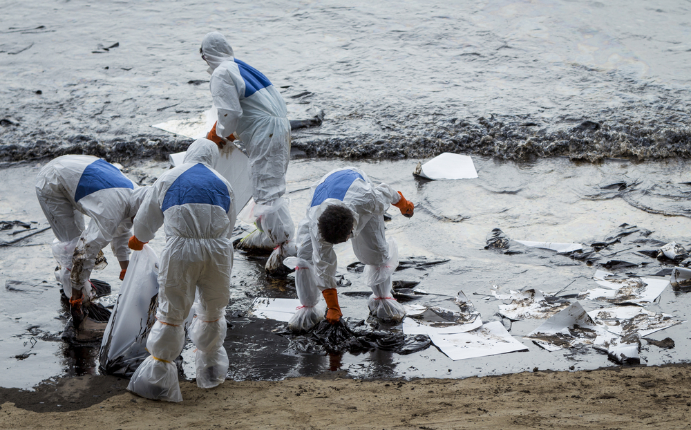
What SCAT Teams Do
You will need a SCAT coordinator who directs the teams’ activities. That is because the SCAT teams will never be acting in a vacuum. They must be collaborating with the at-sea response teams and others who have responsibility for divergent aspects of the response, such as communications with the public and local community.
SCAT teams prepare field maps and other forms to provide details on the affected (and potentially affected) areas and recommend specific cleanup actions. Those recommendations may change as the response evolves. SCAT teams serve as advisors, not managers or directors of the environmental response; that is an important distinction. They inform directors and supervisors but don’t, themselves, issue direction.
SCAT teams need to assess a variety of impact issues:
- Potential for human exposure, by direct contact or consumption through food and beverage source contamination
- Extent and duration of environmental impact if oil is left to biodegrade
- Natural removal rate
- Potential for remobilized oil to affect other sensitive resources
- Likelihood cleanup could cause more harm than oil alone
Since different shoreline environments respond differently to oil types and possible chemicals and physical methods used in cleanup, a full assessment of the affected area’s sensitivities should be made, including projections into the future, which include marine- and shore-life reproduction, human habitation and business, and long-term natural resource damage. You may encounter constraints on your cleanup methods, especially if a response that is optimal for one ecosystem is harmful to another.
Knowing your end point is crucial. If you don’t know what success looks like, you are not likely to now when you have achieved it, and you will not be able to communicate your goals and accomplishments as you attain them. Part of defining success is knowing what the affected area looked and behaved like before the spill and what it looks like as the contaminant invades and is removed from the area. Luckily, there has been much work done on cataloging and refining sensory and imagery data from many coastal areas, which is available for the purposes of oil-spill response planning and implementation. Aerial imagery is a key component to the production of spill-response data. In our next blog, we’ll look at some of the complexities involved in aerial data collection and use.
About WQIS
Since 1971, WQIS has been involved in more vessel pollution events than any other marine pollution provider. Having the right team immediately available in the event of a loss is crucial for mitigating damages, getting clients back to an operational status and the claims process. Our team is made up of an extensive network of trusted professionals to assist from the moment a spill occurs until the spill is cleaned up. For more information about our insurance solutions and services, call us at 212-292-8700.
Source: NOAA